

Published Aug. 14, 2:26 p.m. | Updated Aug. 17, 8:30 a.m.
Smoke from at least 12 wildfires fires burning across Colorado and beyond continues to hang over large parts of the state. Periods of moderate to heavy smoke are expected. State health officials warn that people with respiratory illnesses, the very young and elderly may want to remain indoors if the smoke is heavy.
Here are the latest updates on fires burning across the state.
Cabin Lake Fire Near Meeker
All forest and BLM lands west of Main Marvine trail and drainage were closed Thursday afternoon because of Cabin Lake Fire activity, according to the White River National Forest’s Facebook page. The closure includes the entire South Fork drainage and all associated trailheads and campgrounds. All forest land east of the West Fork of North Elk Creek and south of Buford and Lake Avery to the Blanco District Boundary are also closed. Rio Blanco County Road 12 and the Main Marvine Trail was not affected.


The fire burned 5,188 acres and was 29 percent contained Friday morning, according to the Sheriff’s Office’s Facebook page.
Extreme fire behavior on Tuesday evening prompted additional mandatory evacuations for residents on County Road 10. County Road 17 remains under a pre-evacuation.
Other restrictions and closures:
The Buford New Castle Road remains closed at the intersection of County Road 10 and County Road 17 and south to the turnoff to the Meadow Lake Campground (Forest Service Road 601).
County Road 10 is open to residents only between the intersection of County Road 10 and County Road 17.
An emergency area closure remains in place on the Blanco Ranger District of the White River National Forest. All trailheads and campgrounds in the South Fork drainage are closed.
A temporary flight restriction remains in effect.
Smoke columns on were more than 23,000 feet high. The fire may be seen from Garfield, Eagle, Summit and Routt counties. Cabin Lake Fire is burning about 5.5 miles from Buford and 7 miles northwest of Meadow Lake Campground near Meeker.
For more evacuation information call the Rio Blanco Sheriff’s Dispatch Center at 970-878-9600 or sign up for their alerts.
Silver Creek Fire Near Kremmling
The Silver Creek Fire was active to the north and south Thursday evening. It spread east toward 131 Road on the north end and moved east between Latigo Rand and the Old Park subdivision on the south side, according to Grand County Sheriff’s Office.
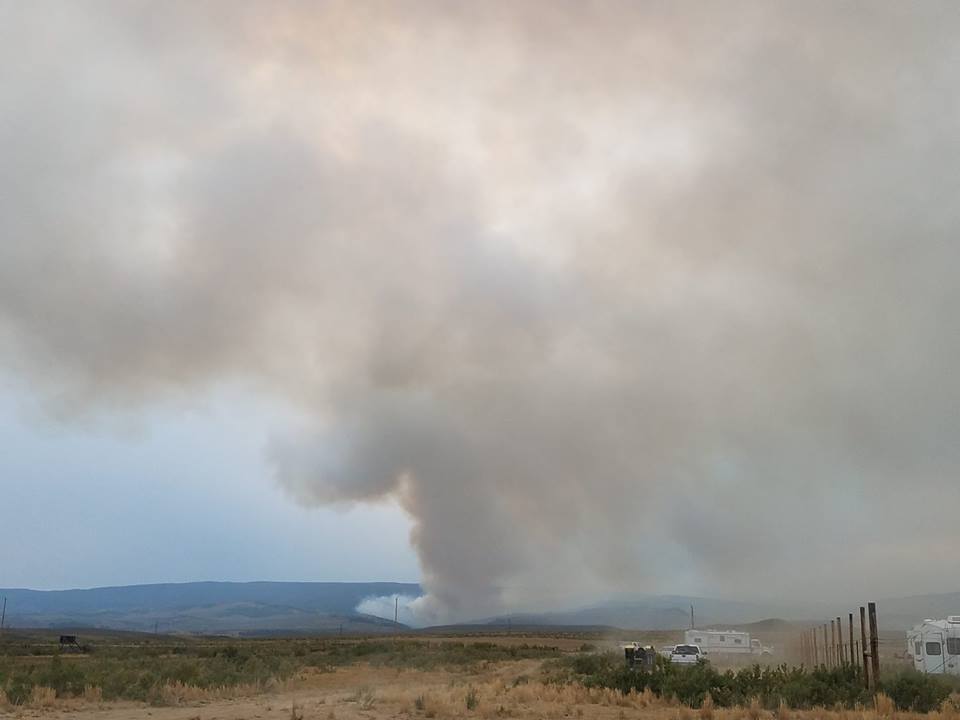

The Silver Creek Fire burned 4,098 acres and was 5 percent contained Thursday evening, according to Grand County Office of Emergency Management’s Facebook page. Grand County is under stage 1 fire restrictions.
About 200 homes were affected after officials put the Old Park and Gore Lakes communities under a mandatory evacuation late Wednesday evening because of Silver Creek Fire movement. They were previously under a pre-evacuation. Latigo Ranch is still under mandatory evacuation.
A Red Cross Shelter was set up at West Grand Elementary School at 715 Kinsey Ave. An informational sign up was be available at an Emergency Medical Station at 1003 Eagle Ave.
Other closures and restrictions:
All County Roads west of County Road 19 off of Highway 134 to the Grand/Routt County line are closed to the public.
State Highway 134 from milepost 16 to 25 is closed to all traffic.
Structure protections teams will be in the Latigo Ranch area Thursday. Lt. Dan Mayer of the Grand County Sheriff's Office told KUSA-TV that about 30 guests, 15 to 20 employees and some horses left Latigo Ranch late Monday.
Bull Draw Fire Near Nucla
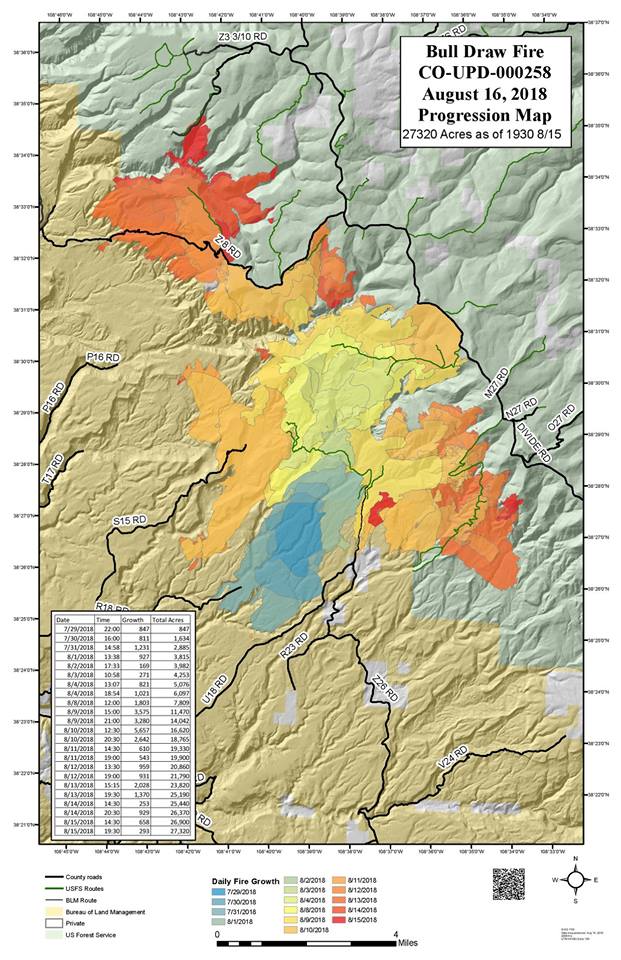
The Bull Draw Fire grew to 28,000 acres by Friday morning and was 21 percent contained, according to the fire’s Facebook page, managed by Bull Draw Fire staff in Nucla.

Montrose County was under Stage 1 fire restrictions on Friday, according to a news release from the BLM. Fireworks and open campfires are not allowed among other restrictions. Unincorporated Mesa County remains under Stage 1 restrictions.
The fire has grown about 3,000 acres since Tuesday and is the 17th largest wildfire in state history, according to the Denver Post.
Other closures and restrictions:
A 17-mile section of the Divide Road remains closed. The closure is from the junction of Brushy Ridge National Forest Service Road #408.
Divide Road NFSR #402, to the Windy Point junction National Forest Service Road #600.
Divide Road National Forest Service Road #402. For questions concerning this closure please call the Grand Valley Ranger District at 970-242-8211.
The fire was burning 12 miles northwest of Nucla on the Western Slope close to the Utah border. It started on July 29 from a lightning strike.
Lake Christine Fire Near Basalt
The Lake Christine Fire was more active on Wednesday afternoon due to warm temperatures and low humidity, torching unburned fuel within the fire perimeter.
After over a month of firefighting operations, the Lake Christine Fire continues, burning 12,588 acres, according to Inciweb. The fire is 90 percent contained and is burning 1 mile away from Basalt near Fort Garland.
Warm and dry conditions make fighting the fire difficult, officials there say. But the potential for the fire spreading is minimal at the moment
The Lake Christine Fire began July 3 and spread rapidly on July 4, destroying three homes. Authorities said the fire started by using tracer rounds at a firing range. Two suspects in their 20s turned themselves in on July 15.
The 25-acre brush had fire shut down I-70 in both directions for several hours Tuesday afternoon near De Beque Canyon.
The fire is believed to be started by a cigarette, said Megan Terlecky, spokeswoman for Mesa County Sheriff’s Office.
“Conditions are so dry that it took off quickly,” she said. “We cannot stress how severe the fire danger is out there we had we had a ton of resources on it very quickly to get a handle on it.”
The fire was reported around 11:30 a.m. Tuesday and it jumped the interstate. I-70 reopened later around 4:30 p.m., causing an hours-long delay for drivers. This was the second time this year that section of the highway has been closed because of a fire, Terlecky said.
Cache Creek Fire Near Battlement Mesa
The Cache Creek Fire was 40 percent contained and has burned 2,520 acres by Friday morning, according to Inciweb. Winds caused a spot fire across fire lines on the northwest edge of the fire above Cache Creek Road on Sunday night. The fire was 60 percent contained before the fire spot, but the darkness, intensity of fire and terrain made it unsafe for firefighters to pursue it.
Grand Valley Fire Protection District firefighters and engines protected structures north of the fire near Battlement Mesa east of Grand Junction. Cache Creek Fire was caused by lightning.
Red Canyon Fire Near Rangely
The Red Canyon Fire, 30 miles south of Rangely, burned 5,722 acres on Friday morning. The fire was 100 percent contained, according to Inciweb. Public lands in Rio Blanco and Garfield counties were temporarily closed on Aug. 1 by the Bureau of Land Management but were lifted late Tuesday morning. The fire started July 29 by lightning.


Moccasin Mesa Fire Near Mesa Verde
The Moccasin Mesa Fire has burned 185 acres near the Southeast boundary of Mesa Verde National Park. The fire is 100 percent contained, according to InciWeb. It was reported by Park Point Lookout on Aug. 4 and was caused by lightning.
Plateau Fire near Dolores
The Plateau Fire in the San Juan National Forest northeast of Dolores and the McPhee Reservoir has burned 19,554 acres and was 95 percent contained on Thursday morning, according to Dolores Ranger District. Firefighters were working on the northern edge of the fire where a few small sections were uncontained. The fire has been burning since July 22 and was caused by lightning.
The Plateau Fire on #SanJuanNF is 93% contained and the Dolores-Norwood road, Boggy Draw road and House Creek roads are open as well as the Dolores overlook trail. The map below shows the new Plateau Fire closure area. pic.twitter.com/9YLIRr7m0X
Green Mountain Fire Near Gunnison
The Green Mountain Fire, burning 25 miles southeast of Gunnison, was 100 percent contained. Fifty-three acres burned, according to a news release from the U.S. Forest Service. The cause of the fire is unknown and no damages were reported.
Sugarloaf Fire Near Fraser
The Sugarloaf Fire burned 1,280 acres and was 35 percent contained by Aug. 10. The fire is 13 miles southwest of Fraser and was started by lightning.
Buttermilk Fire In Gunnison Gorge
The Buttermilk Fire, burning in the Gunnison Gorge National Conservation area, burned 748 acres and was 70 percent contained Aug. 8. The C77 Road was closed to the public. Smoke may be visible in Delta and Montrose counties.
West Guard Fire Near Dove Creek
The West Guard Fire, burning 13 miles east of Dove Creek, northwest of Dolores, was caused by lightning. It was 100 percent contained and had burned 1,424 acres. The fire was started by lightning and was discovered by a helicopter working on the Plateau Fire.
The Associated Press contributed to this report.
Correction: A previous version of this story incorrectly stated who manages the Bull Draw Fire Facebook page. Bull Draw Fire staff in Nucla and assigned to the fire manage the page.


