Editor's Note: This post collects all of our reporting on the wildfires burning in Colorado for Wednesday, Aug. 19. 2020. You can find the latest updates here. Our original story continues below.
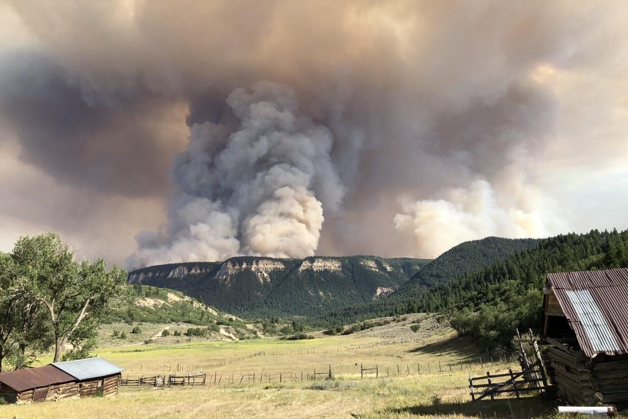
The Pine Gulch’s reign as the third-largest fire in Colorado didn’t last long. Massive overnight growth — fueled by a thunderstorm — has propelled the fire to second place.
The number two spot had been held by 2018’s Spring Creek fire which burned 108,045 acres two summers ago near La Veta and the Sangre de Cristo mountains. Pine Gulch, north of Grand Junction, now stands at an estimated 125,100 acres.
“A large thunderstorm cell moved through the area early this morning,” said information officer Tracy LeClair. “We had significant growth in the northwest corner of the fire.”
As of Wednesday, 892 people are working on the blaze, and “the growth last night will probably prompt additional ordering” of resources, LeClair said. “The good news is we're able to shift some of those crews that were working in the areas where we have containment.”
More than 2,400 firefighters are engaged in the massive effort to combat wildfires across Colorado right now. To the east, the Grizzly Creek fire continues to consume Glenwood Canyon.
"Just going back to the canyon is going to be sad because that's beautiful, and Hanging Lake, and destroyed childhood scenes and stuff," said Vladimir Carbajal, a lifelong Eagle County resident. "We've been going there since I was a kid."
Several new fires broke out around the state Tuesday. The governor has ordered a 30-day statewide fire ban, as the extremely hot, dry weather continues. Nationally, 22 new large fires were reported on Tuesday. Across 14 states, 77 large fires have burned 649,054 acres.
The increase in fire activity across the country has raised the national preparedness level to the highest ranking. Fire officials note that this would create competition for resources.
Here are the current statuses of Colorado’s four major wildfires (click on the fire name to jump to the updates):
- Grizzly Creek Fire: 28,030 acres, 4 percent containment (Aug 19, 6:04 p.m.)
- Pine Gulch Fire: 125,100 acres, 7 percent containment (Aug 19, 6:00 p.m.)
- Cameron Peak Fire: 15,738 acres, no containment (Aug 19, 4:16 p.m.)
- Williams Fork Fire: 6,726 acres, 3 percent containment (Aug 19, 3:11 p.m.)
Grizzly Creek
6:05 p.m.: One of the people fighting the Grizzly Creek wildfire is also a member of the governor's cabinet.
Dan Gibbs heads the state department of natural resources. He's also been a certified wildland firefighter for 13 years, and he was recently on a crew working to protect homes near Glenwood Springs.
"I really feel like this is really important for me to be on the ground, to really understand the complexities that wildfires bring to our natural resources," Gibbs said. "How it impacts our water sheds, our communities, our wildlife, and just big picture overall natural resources."
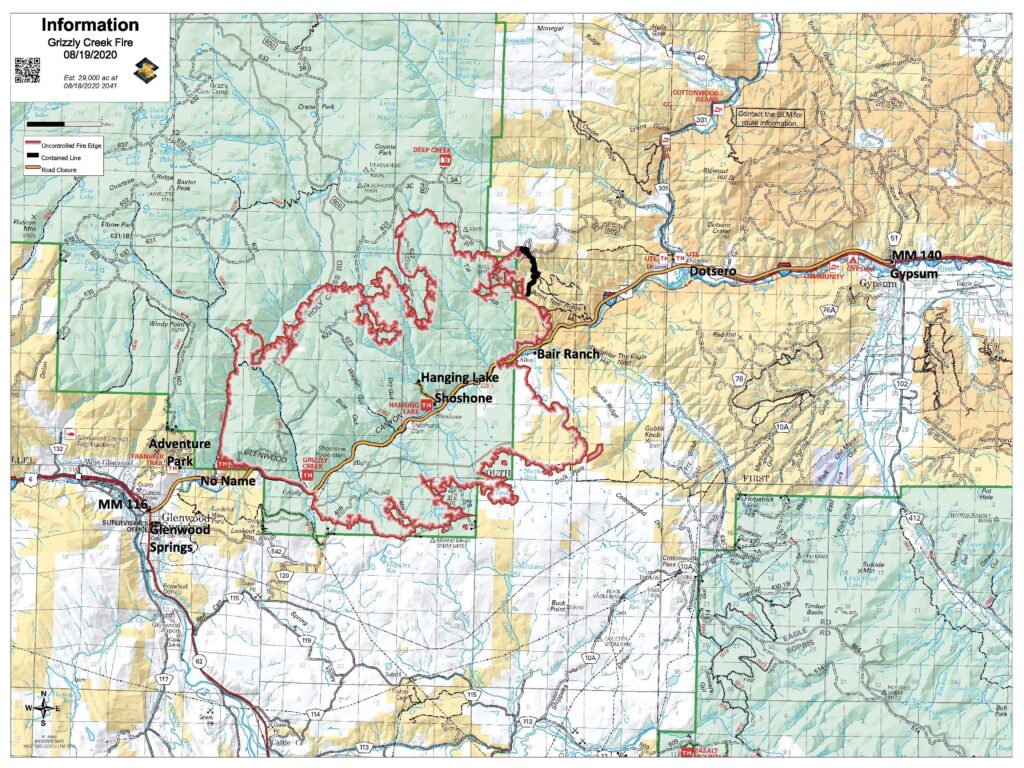
5:44 p.m.: The Grizzly Creek Fire has burned most of Glenwood Canyon.
Public information officer Brian Scott says the burn scar, while spotty in some spots, covers most of the canyon from No Name to Bair Ranch.
“The fire has burned down the sides of the valley. There’s hardly any, if any, unburned areas along the highway,” Scott said Wednesday afternoon.
The fire consumed trees and other vegetation that help hold rocks in place, and subsequently resulted in more rocks falling onto Interstate 70.
“A boulder the size of a Volkswagen came crashing down, went across the north lanes and onto the south lanes and broke out a piece of the guard rail,” he said.
I-70 has been closed for more than a week. A Colorado Department of Transportation spokesman says the agency has been assessing the road throughout the fire, as safety allows. There’s no timeline yet for its reopening.
The fire has mostly moved to the northwest, Scott said. It's four percent contained.
— Nate Minor
7:19 a.m.: Investigators now believe the fire in Glenwood Canyon was caused by something dragged beneath or behind a vehicle on Interstate 70. The resulting sparks may have lit dry vegetation on the side of the highway.
Glenwood Springs resident Kyle Jone was tubing on the Colorado River on Aug. 10, the day the fire started. When he first saw smoke floating near I-70, he assumed it was another small roadside fire — "It quickly became apparent that it was much worse than that," he said.
Pine Gulch
5:53 p.m.: FEMA has approved a Fire Management Assistance Grant to help fight for the Pine Gulch fire.
The funds can be used to pay 75 percent of Colorado's "eligible firefighting costs," which FEMA defines as "managing, mitigating and controlling designated fires."
The wildfire north of Grand Junction is currently the largest burning in the United States, according to the National Intragency Fire Center.
3:17 p.m.: There are new evacuation orders for people living near the wildfire burning north of Grand Junction. The rapid growth to the northwest prompted the Garfield County Sheriff’s Office to evacuate people in that area including Highway 256 and Highway 205. The residents there were already on pre-evacuation notice. Now, everything west of the fire to the Utah state line is in pre-evacuation.
- From the Mesa County line north to the east/west Colorado Highway 256, including north/south Colorado Highway 256. 256/205 moving from pre-evacuation to full evacuation
- From Highway 139 Douglas Pass road east to the preexisting evacuation order for Carr Creek Road (207)
- CO Hwy 205 Salt Wash and Kimball Creek Road (202) on Kimball Mountain
- CO Hwy 258/King Road is evacuated
— Alison Borden
1:19 p.m.: Here's what the fire looks like first hand.
12:05 p.m.: Last night, the federal government elevated the National Preparedness Level to 5, the highest level, due to dozens of wildfires breaking out across the western United States. According to the National Interagency Fire Center, this means at least 80 percent of the country's wildland firefighting personnel are deployed to fires nationwide.
On a local level, this means fire teams will struggle to obtain much-needed personnel. Colorado’s largest current wildfire, the Pine Gulch Fire, has over 890 personnel deployed to help contain the spread. Public information officer Tracy LeClair said they need more after massive overnight growth.
"At this point, we have been a very high priority in the state and in the nation," LeClair said. "So we are still receiving the orders that are being placed. They're just reevaluating based on the growth early this morning to see what additional resources they may want to place orders for today."
— Paolo Zialcita
10:50 a.m.: Overnight weather created "extreme and erratic fire behavior" which drove significant growth of the fire. The combination of weather conditions, dry fuels and wind will likely continue to drive growth. Meteorologists expect a similar storm pattern to occur again over Pine Gulch in the afternoon or overnight.
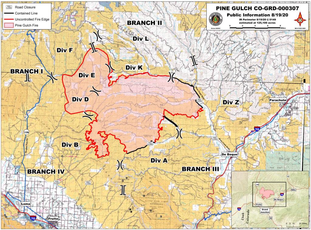
7:19 a.m.: There are dozens of oil and gas wells in and around the perimeter of the Pine Gulch fire. Fire official Pat Seekins said some facilities in the southwest portion of the fire have been confirmed as damaged. He noted that they’re working with companies in the areas to protect infrastructure from fire damage.
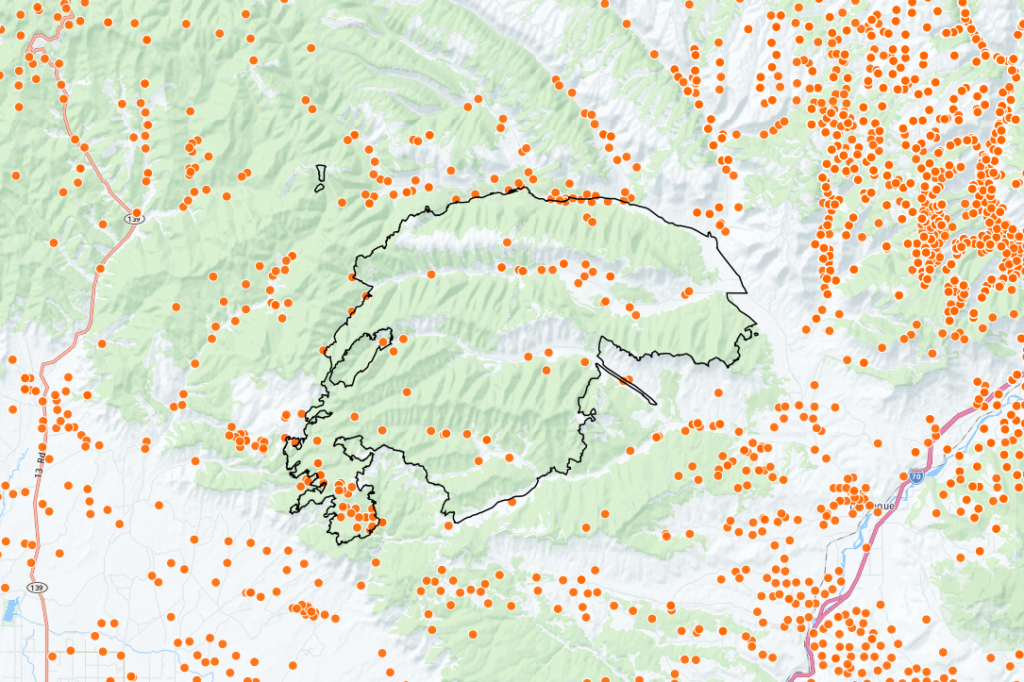
"Identifying those gas lines, those oil well sites that are of concern, whether they're threatened or damaged, so they can get assessments of where the fire is going," he said. "We want to get ahead of that, which we feel like we are."
Seekins said most oil and gas infrastructure has been unaffected by the fire, and that threat assessments are ongoing.
— Paolo Zialcita
Cameron Peak
2:41 p.m.: There will be a virtual community meeting tonight.
2:28 p.m.: The investigation team working to pinpoint the cause of the Cameron Peak fire is asking the public for help. They are looking for any photos taken from the trails located to the south of Cameron Peak. In a release, the Forest Service says the "most helpful photos would be those taken of active fire adjacent to any of the adjacent trails, especially of smoke and flames located near these trails." Photos can be emailed to [email protected] or, if you have any other information, you can call 307-745-2392, option 5.
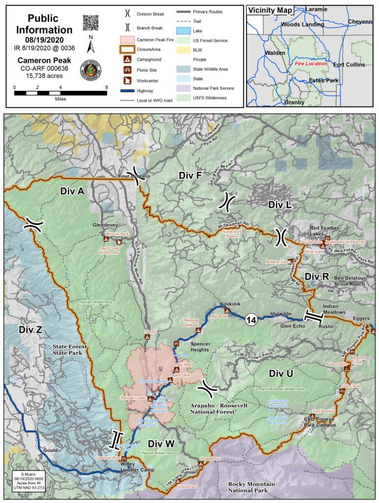
7:19 a.m.: Officials say Wednesday's weather will make fighting the Cameron Peak fire more difficult.
"We're going to see some north winds, 10 to 20 miles per hour, but we’re also going to be seeing these thunderstorms that will be coming through, not dropping a lot of rainfall, potentially putting down lightning and having strong, gusty winds with them as well," said Darren Clabo, a meteorologist with the Rocky Mountain Incident Management Team.
The fire’s growth has been to the south and it’s now 4 miles away from the northwest boundary of Rocky Mountain National Park. The park announced closures in that area because of the forecast winds and extreme fire conditions.
Williams Fork
6:08 p.m.: Firefighters at the Williams Fork fire managed to contain a small part of the burn despite dust storms and lightning.
Public information officer Robin Broyles Broils says they’re trying to keep the fire from hitting a nearby county road.
"That section of the fire is burning on a very steep, rocky slope, and it's not moving very quickly. So we are using that roadway as a containment area," Broils said.
— Paolo Zialcita
11:05 a.m.: There was only a small increase in the size of the fire, a few hundred acres, according to fire managers. Fire activity continues within the perimeter and a large smoke column remains visible. On Tuesday night, Great Basin Type 1 Incident Management Team 2 assumed overall command of the fire.
7:19 a.m.: Officials say that trees killed by the mountain pine beetle are helping to fuel the fire. Information officer Schelly Olson pointed out that the dead trees are "a fuel type that's very dangerous to work in."
The Williams Fork is 6,627 acres in size and burning on National Forest land west of the town of Fraser. Firefighters have started to establish some minor containment.


