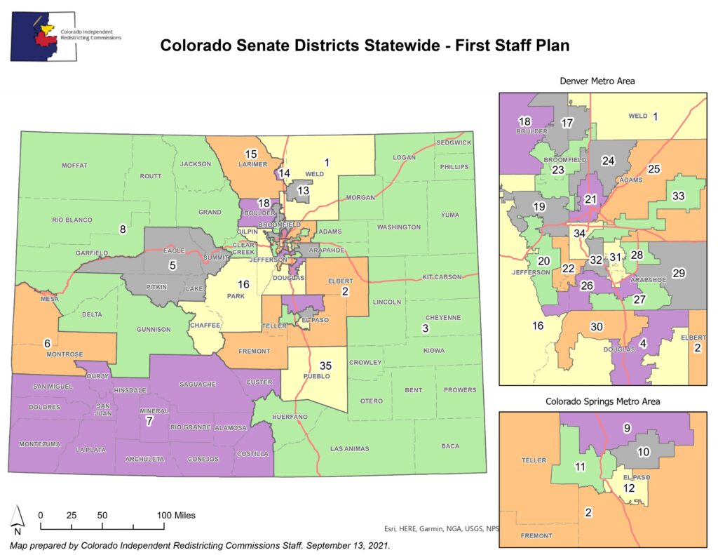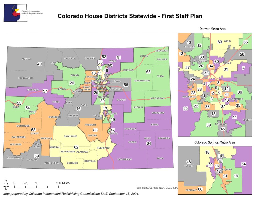
After a summer of public hearings, draft state House and Senate maps created by a nonpartisan staff are ready for review.
The maps are just a proposal at this point. From here, the commission will debate possible changes and can ask staff to redraw the lines several more times before they have to settle on a final version at the end of this month.
View details of the draft state legislative maps here.
One thing stands out with the numbers on this new map — it would give Democrats solid control at the state legislature for years to come.
To calculate how competitive a district might be, staff added up its results for eight recent elections — the 2016 Senate and presidential contests, five statewide races in 2018, and the 2020 U.S. Senate race — and created an average.
In this new map, out of the Senate’s 35 seats, 20 lean strongly Democratic while 11 are strongly Republican. Four seats might be considered potential swing districts — that is, the average election results favored one side by 5 percent or less.

In the House, the new map would give Democrats a 13-seat advantage, 36 to 23, with six districts where the party advantage is 5 percent or less.
Those swing districts would be scattered around the state — they include the districts for far southwestern Colorado (SD7 and HD-59), Greeley-Evans (HD-50), parts of Colorado Springs (SD-11, SD-12 and HD-16), the mountains west-southwest of Denver (SD-16) and three seats in Denver’s southern suburbs (HD-22, HD-35 and HD-38).

Currently, Democrats hold a 20-15 majority in the Senate and a 41-24 majority in the House.
Republicans criticized the lack of competitiveness.
“We agree with the assessment provided by others in the media that this map will consistently elect a Democrat majority in the state House and state Senate. This process has a long way to go, and we hope the commission will work to generate more competitive districts,” said Joe Jackson, the executive director of the Colorado GOP.
One issue that has been front and center in the discussion of redistricting is how to fairly capture the state’s Latino population within the political map.
The first maps put out by staff earlier this summer, which they described as a “starting point” that had to rely on incomplete census data, had 12 House seats and seven Senate districts where 30 percent or more of the population identifies as Hispanic.
This new map increases that slightly, to 13 districts in the House and eight in the Senate. That still falls short of a map proposed by the Latino advocacy group CLLARO earlier in the process.
In response, CLLARO said in a statement that while it appreciated the improvement in the maps, the group is still disappointed with some of the changes made in the new maps.
"Commission staff adopted and improved several of our recommendations by preserving communities of interest in the Roaring Fork Valley and around Colorado Springs in the House maps," the statement reads. "But where the Commission maps missed the mark — and dramatically so — was by diluting the votes of Latino communities in Adams and Weld counties, particularly in the Senate maps."
The legislative redistricting commission will hold two virtual public hearings on the new maps at the end of the week. Final House and Senate maps must be submitted to the state supreme court by October 11.
Editor's Note: This story has been update with CLLARO's response to the maps.
- Colorado’s Redistricting Committee Just Released A New Map, And It Looks Pretty Different From The Last One
- From Dinners To Podcasts, Communities Of Color Spread The Word About Redistricting
- When It Comes To Redistricting, Where Does Southern Colorado Fit In?
- Hitting The Road To Get To Know Colorado’s New (Maybe) Eighth District


